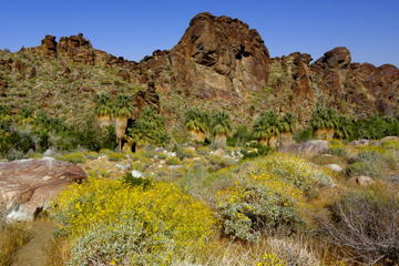
San Andreas Fault
TIME : 2016/2/22 16:51:45

San Andreas Fault
Home of the potential Big One! The San Andreas Fault is an 810-mile (1,300-kilometer) long continental transform fault located in California, which forms the tectonic boundary between the Pacific and the North American tectonic plates. The fault is most famous for having reached a sufficient stress level for what is commonly referred to the next "big one," a 7.0+ magnitude earthquake on the Richter scale. Both the public and the scientific community continue to speculate on the size and date of the next earthquake, and most importantly the potentially catastrophic damages caused by it, considering that California is the densest state in the United States. However, scientists have concluded that quakes on the Cascadia subduction zone, which stretches just a little further up north from Vancouver Island to northern California, may have triggered most of the major quakes on the fault within the past 3,000 years – including the disastrous 1906 San Francisco earthquake.
At just over 28,000 years old, the San Andreas Fault is still growing at a rate of 2.5 inches per year, constantly reshaping California. But despite being named a fault, San Andreas is almost exclusively horizontal, stretching in a right-lateral strike-slip.
Practical Info
The San Andreas Fault is divided in three distinct zones and it is possible to visit each one of them. The northern part can be visited in Pinnacles National Park, famous for its unique rock formations. The central part is most famous for the San Andreas Fault Observatory in Parkfield, which has moved more than five feet since 1936. Lastly, the south part begins near the San Bernardino Mountains just outside of Los Angeles and runs east to the San Gabriel Mountains, with Palm Springs being the best places to physically explore the fault, as well as the oasis and the hot springs it created. Palm Springs is located 1 hour and 45 minutes (107 miles/172 kilometers) southeast of Los Angeles.
