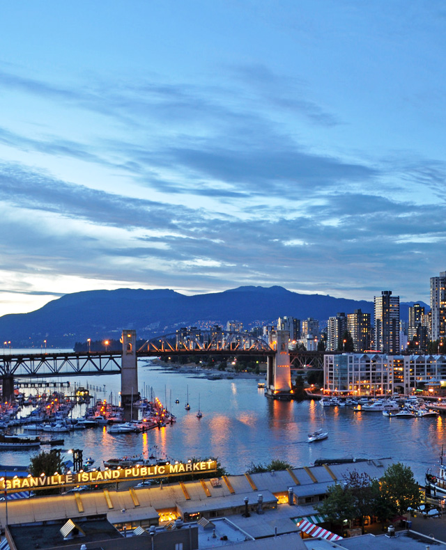
Vancouver’s downtown is almost an island, bordered on three sides by False Creek, English Bay, and Vancouver Harbour, which encourages the buildings there to grow tall. Photo © Harshil Shah, licensed Creative Commons Attribution and NoDerivatives.
But the outdoors is never far away, with waterfront areas, a spectacular city park, and mountains right next to downtown. The Stanley Park bike path takes pedal pushers past woods, beaches, and rocky shores while just across the Harbour is Grouse Mountain, with skiing or snowshoeing accessible by city bus.
Although Vancouver’s population is slightly smaller than Seattle’s, it feels bigger thanks to its great variety and modern, glassy architecture. Canadians show off their famously friendly disposition on the city streets and even the mountains that tower over Vancouver feel welcoming.
The main route through Seattle is I-5. This multilane road is infamous for its traffic snarls, which are worst during early morning and late afternoon rush hours. The 8-mile-long express lanes, which change direction depending on where the bulk of cars are heading, can be a useful bypass.
Traveling north, I-5 reaches the city of Everett 30 miles north of Seattle. From Everett, there’s usually little to slow drivers until they reach the border crossing 80 miles north in Blaine, Washington.
Though it’s a 20-minute drive from the freeway, the town of Anacortes is worth the detour. From I-5, take exit 230 and follow State Route 20 west for 11.5 miles across farmland and the tidal waters of several sloughs; take the Highway 20 spur north to Anacortes, about 4.5 miles. Anacortes is best known as the departure point for San Juan Island ferries, including one that continues east to Victoria on Vancouver Island. Stop for a bite at Adrift (510 Commercial Ave., 360/588-0653, 8am-9pm Mon.-Thurs., 8am-10pm Fri.-Sat., 8am-2pm Sun., breakfast $5-13, lunch $8.50-17, dinner $15-29), a seafood joint better known for a wide variety of burgers and ice cream floats made with stout or champagne. Or try the barbecue and biscuits at Dad’s Diner (906 Commercial Ave., 360/899-5269, 7am-4pm Tues.-Sun., breakfast $8-10, lunch $8-20). After lunch, walk along the waterfront, where boats sit neatly parked in the bustling marina. Drive south to Deception Pass State Park (Hwy. 20 and Rosario Rd.), which bridges Whidbey Island and the mainland. The bridge that connects the island is either picturesque or terrifying, depending on your fear of heights! Park and cross by foot for the best views.
Two options are available for crossing the border: the Peace Arch crossing at the end of I-5 and the Pacific Highway crossing on Highway 543.
To reach the Peace Arch crossing, stay on I-5 north as it slowly funnels cars directly into the border-crossing lanes. The actual arch sits in a large green park between crossing stations. Take care when letting passengers out to explore the field while the driver waits in line because everyone will need to be back in the car well before the crossing station. Upon entering Canada, the route immediately becomes the Canadian Highway 99.
For the Pacific Highway Crossing (also called Truck Customs, for its use among commercial vehicles), take Exit 275 off I-5. Follow Highway 543 for less than a mile before meeting the border. Once through the border crossing, follow Canadian Highway 15 for several blocks, turn left on 8th Avenue, and then take a right at the roundabout at Highway 99. Though less scenic than the waterfront Peace Arch crossing, the Pacific Highway crossing often has a shorter wait.
Highway 99, also called the Vancouver-Blaine Highway, swings north through the open plains that sit just south of Vancouver’s suburbs. In about 30 kilometers (19 miles), Highway 99 passes through a tunnel under the Fraser River, emerging in the suburb of Richmond.
From Richmond, Highway 99 continues across the Oak Street Bridge. Turn left on W 70th Avenue, and continue north on Highway 99/Granville Street for about 16 kilometers (10 miles) toward the Granville Bridge and downtown Vancouver. Although the route narrows from a highway to surface streets, traffic flows well into the downtown core.
After crossing the Granville Bridge, you’ll arrive in the heart of Vancouver. Follow Seymour Street northeast to continue to the waterfront area and Gastown. Note that several downtown byways are one-way, so check all traffic signs before making any turns.
Two ferry routes travel between Victoria and Vancouver. The Swartz Bay (Hwy. 17, $16.50 adults, $8.15 children 5-12, children under 5 free, vehicles $53.25, surcharges for fuel and large vehicles) route departs from the Saanich Peninsula, 32 kilometers north of Victoria at the end of Highway 17, just north of the town of Sidney. The boat travels to Tsawwassen, located south of the Vancouver-Blaine Highway, a 90-minute trip. From the Tsawwassen ferry terminal (1 Ferry Causeway, Delta), drive north on Highway 17A for 13 kilometers (8 miles), and then take Highway 99 north to Vancouver. The ferry travels 8-17 times per day in each direction. Reservations are recommended.
The second ferry departs from Nanaimo ($16.50 adults, $8.15 children 5-12, children under 5 free, vehicles $53.25, surcharges for fuel and large vehicles), about 110 kilometers (177 miles) north of Victoria along Highway 1. Arrival is at Horseshoe Bay (6750 Keith Rd., West Vancouver), approximately 20 kilometers (12 miles) northwest of Vancouver. The trip lasts about one hour and 40 minutes; ferries run 7-12 times per day in each direction; reservations are recommended. From Horseshoe Bay, drive southeast on Highways 1 and 99 for 20 kilometers (13 miles) to North Vancouver. Highway 99 continues south across the Lions Gate Bridge into downtown Vancouver.
Excerpted from the First Edition of Moon Pacific Northwest Road Trip.