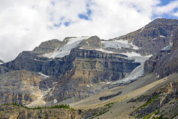
Stanley Glacier
TIME : 2016/2/22 10:08:20

Stanley Glacier
Fire and ice bring plenty of contrast to the Stanley Glacier hike in Kootenay National Park. A major forest fire struck the area in 2003, creating quite the renewed ecosystem. The recovering lodge pole pine forest is littered with colorful wildflowers, which grow abundantly because of the newly fertilized soils caused by the fire. Further up the trail, the forest diminishes as hikers enter the Stanley Basin. Views of the glacier are spectacular from here; however, hikers must scramble uphill, over large boulders, for another kilometer to see the toe of the glacier.
The hike also traverses a thin portion of the Burgess Shale, which is a 505-million-year-old sea bed preserved on the western slopes of the Canadian Rocky Mountains. Joining a seven-hour, 12-kilometer Parks Canada interpretive hike is the best way to take in close-up views of the Stanley Glacier, while also discovering trilobites, hyolithids, brachiopods, sponges and algaes fossils that go missed by the unobservant hiker. These hikes are popular and reservations must be made in advance.
Practical Info
The Stanley Glacier trailhead is located on Highway 93 in Kootenay National Park, just 15 kilometers south of Castle Junction and 45 kilometers from Banff, Alberta. It is located 95 kilometers north of Radium Hot Springs, British Columbia.
