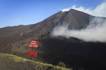
Pacaya Volcano
TIME : 2016/2/22 11:10:00

Pacaya Volcano
Pacaya Volcano is considered Guatemala’s most active volcano and is believed to have first erupted approximately 23,000 years ago. Pacaya has erupted a number of times since and has had an active status since 1965. It stands at more than 8,300 feet (2.5 km) at its tallest point and is part of the Central American Volcanic Arc.
One of the most notable eruptions was in 2010, when Pacaya erupted multiple times in one day, raining ash on a number of towns, including part of Guatemala City. Schools and the airport were affected by the raincloud of ash, causing the president to declare a state of calamity. This was further complicated by torrential rain from Tropical Storm Agatha, which had caused flooding and landslides in the region. In March 2014, Pacaya erupted again, and officials discussed whether to evacuate several thousand people who lived near the volcano’s base. This eruption sent another huge ash cloud into the air and caused a number of flights to be diverted.
Despite Pacaya’s active status, it remains one of the most popular tourist destinations in Guatemala. Hikers stop along the caldera’s lagoon to marvel at the views of Agua, Fuego and Acatenango, all neighboring volcanoes. If you continue up, you will have even better views of both the Guatemalan landscape and Pacaya’s main crater. Due to safety reasons, visitors are not permitted to visit the crater itself, but you can’t miss the red-flowing lava and steam baths.
Practical Info
Pacaya Volcano is conveniently located near Guatemala City and Antigua, making tours possible from either city. Most tours to Pacaya include a 2.5-hour hike up the volcano with an expert guide. Travelers concerned about the volcano’s status shouldn't worry; officials constantly monitor Pacaya for potential activity and are well equipped to handle emergency situations.
