Rosario
Possibly Argentina’s most underrated city, the economic powerhouse of Rosario is an industrial city and a major port for grains from the pampa gringa, but it also boasts one of the country’s liveliest cultural scenes, with first-rate museums, art, theater, and live music. Among its many creative artists have been comedian Alberto Olmedo, actress Libertad Lamarque, actor Darío Grandinetti, and pop musician Fito Páez.For nationalists, Rosario is the “Cuna de la Bandera” (Cradle of the Flag), where General Manuel Belgrano designed and first displayed the colors that still wave over the republic today. For Rosarinos themselves, it’s the country’s “second city,” though they have to argue the point with residents of Córdoba.
Sensibly sited Rosario mostly occupies high ground above the Paraná floodplain; when it rains heavily, though, many intersections and even sidewalks can flood, and residents remove their shoes and roll up their trouser legs to get around. Beyond the densely built downtown, tree-lined streets and open spaces like Parque Independencia are the rule. On the floodplain itself, most structures are port facilities or recycled port facilities set among open green spaces.
The first Europeans settled around 1720, moving southward from the city of Santa Fe. Following the mid-19th-century civil wars, the railroad to Córdoba made Rosario a major port and spurred agricultural colonization through the Central Argentine Land Company. New European settlers arrived directly from Europe rather than through Buenos Aires, and by the early 20th century Rosario’s population of more than 200,000 exceeded Santa Fe’s. Because of its late growth, the best parts of Rosario’s cityscape reflect that era’s Francophile preferences—or pretensions.
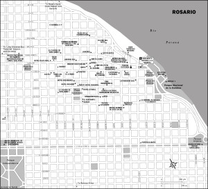
On the Paraná’s west bank, Rosario (pop. about 960,000) is 320 kilometers northwest of Buenos Aires via RN 9, a four-lane toll road that also leads west to Córdoba (as a two-lane highway). It is 167 kilometers south of Santa Fe via A-008, another four-lane toll road, and now linked to the nearby city of Victoria, Entre Ríos, via a 57-kilometer series of bridges and causeways across the Paraná Delta.
Excerpted from the Third Edition of Moon Argentina.