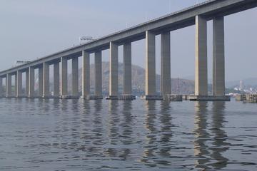
Rio Niteroi Bridge
TIME : 2016/2/22 10:00:39

Rio Niteroi Bridge
Connecting the distant shores of Guanabara Bay—the wide expanse of water bordering Rio to the east that the first Portuguese explorers in Brazil assumed to be the mouth of a river one sunny New Year’s Day just over five centuries ago—the Rio Niteroi Bridge remains one of the country’s engineering marvels. First conceived in 1875 and finally opened 99 years later, the 8.25-mile-long bridge carries an average of 140,000 vehicles a day between Rio and the city of Niteroi, former capital of the federal state of Guanabara (now merged with Rio de Janeiro state) and home to the remarkable Oscar Niemeyer-designed Museum of Contemporary Art (MAC).
Officially named for former Brazilian president Lucio Costa e Silva, the bridge rises to 236 feet at its highest point and was the world’s second-longest span when it opened in 1974, trumped at the time only by Louisiana’s Lake Pontchartrain causeway. While not as picturesque an experience as the ferry link across the bay, the views from the bridge heading west into Rio are still stunning, with downtown Rio, Sugar Loaf, and Corcovado all striking a picture postcard pose. Scores of low-flying jets landing at nearby Santos-Dumont airport every few minutes also add to the spectacle.
